

Structured and unstructured data sat in separate repositories a legacy application couldn’t bring together.
The client is a US military command responsible for planning and conducting missions that bolster global security and stability. By leveraging highly trained forces and advanced strategies, the command ensures rapid, effective responses to the most urgent threats around the world. Its mission depends on immediate access to actionable intelligence, which makes the condition of its information systems an operational question rather than an IT one.
That access ran through a legacy application the command had outgrown. As operational demands intensified, the outdated system struggled to handle both structured and unstructured data arriving in diverse formats, from electronic forms and documents to hand-written entries, images, and videos, which left users with cumbersome searches and a user interface ill-suited for timely information retrieval. Field operators were often deprived of real-time access to crucial data repositories, which undermined their situational awareness and agility in dynamic environments. The system also lacked the capability to generate comprehensive, data-driven reports vital for in-depth analysis and strategic decision-making. These limitations posed serious risks to the command’s effectiveness and the numerous critical programs it supports.
A US military command’s structured and unstructured intelligence sat in separate systems with no common index, slowing analysis when speed mattered most. i3solutions built a data fusion platform that consolidates every format into one searchable interface without losing legacy access.
Faceted search across structured, unstructured, and ad-hoc data now returns faster, more accurate results, field operators get real-time access plus offline data entry through standardized forms, and the legacy systems it replaced were consolidated into one platform, cutting maintenance costs.

The Data Arrived in More Shapes Than the System Could Index
The command’s information problem was one of format before it was one of scale. Source material arrived as electronic forms and documents, as hand-written entries, and as images and video, and the legacy application was built for none of it. Structured records and unstructured content sat in separate repositories with no common index, so answering a question meant knowing in advance which system held the answer and then searching that system on its own terms.
The shortfall widened as operational demand rose. The legacy application became increasingly inadequate rather than merely dated, and the gap showed first where it mattered most: field operators without real-time access to crucial data repositories, and leadership without the data-driven reports that in-depth analysis and strategic decision-making require. What the command needed was multi-source data consolidated into one place and made searchable, not another repository added to the set.
This command’s data sources were consolidated into a single interface while backwards compatibility kept legacy records intact. If fragmented data sources are the barrier in your environment, migration doesn’t have to mean starting over.
Decisions Made Without the Whole Picture
Left in place, the legacy application’s limits were not an administrative inconvenience. They undermined situational awareness and agility in dynamic environments for the people working furthest forward, and they posed serious risks to the command’s effectiveness and to the numerous critical programs it supports. A search that is cumbersome at a desk is a search that does not happen in the field.
The reporting gap compounded it. Without the capability to generate data-driven reports, in-depth analysis rested on whatever an analyst could assemble by hand from systems that did not talk to each other. Every hour spent rebuilding a picture the data already contained was an hour not spent acting on it, and the connections that stayed hidden across multi-dimensional datasets were exactly the ones nobody knew to go looking for.
Fusing Many Sources Without Stranding the Old Ones
The platform had to consolidate multi-source data into a single pane of glass while staying usable by people whose job is not data engineering. Users needed one interface that answered structured and unstructured searches alike, plus ad-hoc queries, with personalized, role-based access to the information they are responsible for. Security had to tighten rather than loosen as sources were combined, which the platform handles through field-level controls, and the interface had to reduce training overhead rather than add to it.
Two constraints shaped the rest of the design. Historical records could not be abandoned, so backwards compatibility with legacy data was a requirement of the architecture rather than a migration afterthought. And connectivity could not be assumed: field agents needed to capture details where the work happens and upload them later, which made offline data entry through standardized forms part of the core platform rather than an add-on. Compliance ran alongside both, with the solution adhering to DoD Net-Ready and NIEM standards for secure data exchange, access controls, and data integrity.
Senior Microsoft Specialists with Proven Delivery Depth
The requirements defined the delivery profile. This was systems integration and data management work joined to full-lifecycle custom application development: extract, transform, and load pipelines feeding a centralized repository, enterprise search and cognitive search layered over it, a geospatial tier, a collaboration tier, and a data layer holding structured and unstructured content together. It had to meet DoD Net-Ready and NIEM standards, and it had to arrive without stranding the historical records the command still depends on.
The command engaged i3solutions, a Microsoft Partner with 30 years of delivery experience and 1,500+ Microsoft engagements, delivered by an all-senior, all US-based delivery team. The engagement also drew on nearly two decades of human-centered design expertise, which is what the interface half of the problem actually required: the command’s difficulty was not that the data was missing but that finding it took a specialist. Microsoft SharePoint provides the platform’s customized collaborative content management layer, integrated with the open-source and commercial-off-the-shelf components that carry search, cognitive analysis, and geospatial work.
i3solutions designed and developed a modular, highly customizable data fusion platform that consolidates multi-source intelligence into a single pane of glass, with geo-spatial mapping, heat maps, and dashboards over the top. The build ran with an all-senior, all US-based delivery team.
PHASE 01
Source and Search Assessment
i3solutions worked through what the command’s data actually looked like: which sources fed the legacy application, which material arrived as electronic forms and documents and which as hand-written entries, images, and video, and where the searches were breaking down. The assessment set the platform’s scope, its ingestion targets, and the personalized, role-based access model that governs who reaches what.
PHASE 02
Ingestion and Repository Architecture
ETL tools were built to extract, transform, and load source data into a centralized repository, with a MySQL data layer carrying schema design, stored procedures, and API integration across JSON, XML, and REST. Backwards compatibility with legacy data was designed in so historical records carried forward, and the exchange design was held to DoD Net-Ready and NIEM standards.
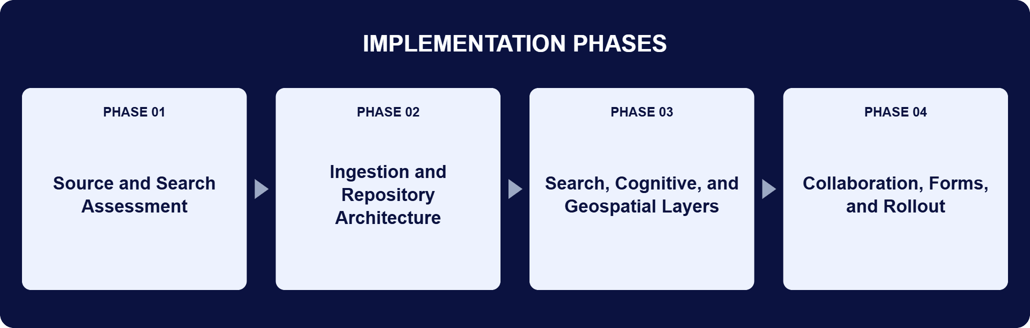
PHASE 03
Search, Cognitive, and Geospatial Layers
Apache SOLR was implemented for automated metadata extraction, classification, and large-scale indexing. IBM Watson Explorer added cognitive search, metadata automation, and relationship mapping across entities such as locations, groups, and events. ESRI ArcGIS brought location-based intelligence into interactive dashboards, and NLP was added for speech-to-text conversion, text analytics, and queries written in plain language.
PHASE 04
Collaboration, Forms, and Rollout
Microsoft SharePoint was customized as the collaborative platform inside the solution, centralizing content management for documents, maps, and intelligence reports with tailored workflows and dashboards. Users were given individual briefcases or workspaces so real-time updates reach everyone without email traffic, offline data entry through standardized forms was delivered for field agents, and Smart Assessment Forms Automation was put in place to hold captured data consistent.
The platform is a fusion stack rather than a single product. ETL tools extract, transform, and load source data into a centralized repository, and a MySQL data layer carries schema design, stored procedures, and API integration, interoperating over JSON, XML, and REST so the platform fits alongside existing military and civil systems. On top of that repository, Apache SOLR handles automated metadata extraction, classification, and large-scale indexing, which is what keeps complex queries fast at this scale. IBM Watson Explorer adds cognitive search: contextual tagging and indexing, metadata automation, and relationship mapping that surfaces correlations between entities such as locations, groups, and events. The geospatial tier is ESRI ArcGIS, which turns search results and reports into interactive dashboards with map overlays. NLP converts speech and text into searchable material and interprets queries written in natural language, while AI and machine learning apply data mining, pattern recognition, metadata auto-tagging, and multimedia processing across structured and unstructured content alike. Collaborative content management for documents, maps, and intelligence reports runs on a customized Microsoft SharePoint layer. Agile methodologies ran the lifecycle, and a high-availability infrastructure with redundancy, disaster recovery, and continuous performance monitoring keeps the platform up.

One Pane of Glass for Field Operators
A single searchable interface with geospatial mapping and faceted search now returns faster, more accurate results across every source.
| Outcome | Before | After |
|---|---|---|
| Multi-source data | Separate repositories the legacy application could not bring together | One centralized repository consolidated into a single pane of glass |
| Search | Cumbersome searches and an interface ill-suited for timely information retrieval | Faceted structured, unstructured, and ad-hoc search returning faster, more accurate results |
| Field access | Field operators often deprived of real-time access to crucial data repositories | Real-time access, plus offline data entry through standardized forms for work without connectivity |
| Reporting and analysis | No capability to generate comprehensive, data-driven reports | Embedded analytics and reporting with geo-spatial mapping, heat maps, and dashboards |
| Legacy systems and cost | Outdated systems maintained in parallel | Legacy applications consolidated into a single platform, reducing maintenance costs |
The change the command’s people meet first is the search. Consolidating data from diverse sources into a centralized repository, indexed by Apache SOLR and read through IBM Watson Explorer’s cognitive search, means personnel uncover critical intelligence quickly and searches return faster, more accurate results. Embedded faceted enterprise search lets them explore data from sources such as DoD intelligence, federal agencies, and NGOs in one interface, and reports and search results can be viewed geographically with map overlays for richer context. Analysts and decision-makers identify and understand connections across multi-dimensional datasets that no single source would have shown them, and intuitive interfaces reduce the training overhead of getting there.
Behind the interface, the platform changed what the command has to maintain and what it can prove. Consolidating outdated applications into one platform reduces maintenance costs and lets the command reallocate resources toward mission activity. IT governance plans, metadata taxonomy, and structured governance processes hold the platform to DoD Net-Ready and NIEM standards, so intelligence stays accessible and secure at the same time and can be shared with partner agencies without loosening controls, with field-level controls governing access to the combined data. AI and machine learning reduce data processing times and support predictive analytics and risk assessment, which takes repetitive work off analysts, while ESRI ArcGIS turns the resulting relationships into something leadership can plan and allocate against.

PENDING-CLIENT-QUOTE
This engagement is relevant for
Less relevant for
Many Sources Behind One Interface, with the Legacy Record Intact
The engagement established that multi-source fusion does not require abandoning what came before. ETL pipelines, a MySQL data layer, Apache SOLR indexing, IBM Watson Explorer cognitive search, ESRI ArcGIS geospatial analysis, and a customized Microsoft SharePoint collaboration layer were assembled into one modular platform that consolidates the command’s data into a single pane of glass.
Backwards compatibility with legacy data safeguards historical records, field-level controls tighten security as sources are combined, and offline standardized forms extend the platform to people working without connectivity. Built modular and future-proof by design, the platform takes on emerging technologies including AI, machine learning, OSINT-driven geospatial capabilities, and Baseball Card layouts rather than requiring the next modernization to start over.
Yes, that was the starting problem for this platform. This US military command’s analysts were working across exactly that mix of structured and unstructured sources with no shared index, so the platform was built to fuse them into a single searchable interface while still meeting DoD Net-Ready and NIEM data-exchange requirements. If your own data spans that same range of formats, that’s the condition the platform was designed to handle, not an edge case.
Through the visualization tools built into the platform: geo-spatial mapping, heat maps, and dashboards. Embedded faceted enterprise search lets users run structured searches, unstructured searches, and ad-hoc queries with personalized, role-based access, so they can explore data from sources such as DoD intelligence, federal agencies, and NGOs in one interface. Reports and search results can also be viewed geographically with map overlays for richer context, and ESRI ArcGIS builds interactive dashboards that visualize relationships, threats, and opportunities across the operational environment. Baseball Card layouts present what the platform knows about an entity in one intuitive view. The result is that analysts and decision-makers identify and understand connections across multi-dimensional datasets quickly, including connections that no individual source system would have surfaced on its own.
Apache SOLR strengthens search and indexing through automated metadata extraction, classification, and large-scale indexing, which delivers high-speed results for complex queries and better data organization. IBM Watson Explorer works alongside it, improving tagging, indexing, and the precision of search results through contextual understanding; its cognitive search, metadata automation, and relationship mapping help users uncover correlations between entities such as locations, groups, and events. NLP contributes on the input side, converting speech to text, running text analytics, and interpreting queries written in natural language so multimedia content becomes searchable material rather than an attachment nobody can find. Underneath all of it, a high-availability infrastructure with redundancy, disaster recovery, and continuous performance monitoring keeps response times consistent rather than letting them degrade under load.
ETL tools drive data extraction, transformation, and loading, enriching the repository from diverse sources and consolidating them into one centralized store. MySQL databases serve as the core data management layer, supporting schema design, stored procedures, and efficient API integration, with interoperability across JSON, XML, and REST APIs so the platform works with existing military and civil systems. The solution adheres to DoD Net-Ready and NIEM standards for secure data exchange, access controls, and data integrity, and open-source and commercial-off-the-shelf components are integrated where they earn their place, which is what makes machine learning, geospatial analysis, and content management affordable to add. Backwards compatibility with legacy data safeguards historical records, so consolidating onto the new platform does not cost the command its archive.
Yes. The platform supports offline data entry through standardized forms, so field agents capture details where the work happens and upload them later. Smart Assessment Forms Automation keeps that captured data consistent and preserves data integrity, which matters most for entries made away from a reviewer. Once uploaded, the data joins the same centralized repository as everything else and is automatically cross-linked to related information. Users can organize their work into individual briefcases or workspaces, which reduces email clutter and means real-time updates reach everyone who needs them rather than the people who happened to be on a distribution list. Together those two capabilities close the gap the legacy application left open, where field operators were often deprived of real-time access to crucial data repositories.
The interface is treated as half the engineering problem. This platform’s difficulty was never that the data was missing; it was that finding anything took a specialist, so i3solutions applied nearly two decades of human-centered design expertise to produce an easy-to-use interface where a structured lookup, a free-text search, and an ad-hoc query all live in one place with personalized, role-based access. The build side is integration rather than replacement: ETL pipelines and a MySQL data layer consolidate sources, best-fit open-source and commercial-off-the-shelf components carry search, cognitive analysis, and geospatial work, and backwards compatibility protects the legacy record. Agile methodologies ran the lifecycle with incremental deliveries, effective change management, and close collaboration among developers, analysts, and end users, so the people who would use the platform shaped it while it was still cheap to change.
i3solutions is a Microsoft Partner with 30 years of delivery experience and 1,500+ Microsoft engagements, with every engagement staffed by an all-senior, all US-based delivery team. This engagement shows the profile at work on a mixed stack: Microsoft SharePoint customized as the collaborative content management layer, alongside ETL pipelines, Apache SOLR, IBM Watson Explorer, ESRI ArcGIS, and a MySQL data layer, all held to DoD Net-Ready and NIEM standards. Fusion work punishes wrong architectural guesses, because every source you connect is a source you then have to keep connected, and senior engineers who have built this shape of system before commit to a design that stays modular as AI, machine learning, and OSINT-driven geospatial capabilities arrive. For organizations weighing similar work, a short scoping conversation establishes what the equivalent build would take in your environment.
The platform’s modular design is what let it absorb AI, machine learning, and geospatial capabilities without a rebuild. We can talk through what a similarly future-proofed architecture would look like for your environment.

US-Based | Est. 1997
© i3solutions. All rights reserved.
US-Based | Est. 1997
© i3solutions. All rights reserved.


